Concept plan that incubates ground-up art and celebrates local heritage
Site Analysis
BUGIS, as part of Singapore Downtown, dates back its history all the way to colonial times which still impacts the district today from its heritage to its connectivity. The Jackson Plan map illustrates the origin of the grid structure that still exists today. Moreover, being a cross junction between the various ethnic community, it has become a melting pot of culture.
According to URA’s Draft Master Plan 2019, Bugis will welcome new park spaces and streetscape improvements to connect the arts and cultural precinct at the Bras Basah-Bugis, Fort Canning, and Civic District that stretches from Kampung Glam to Rochor River.
Bugis today is specified as key art and cultural hub in the middle of the other cultural districts. Significant investments of the art districts were done through programmings such as annual Singapore Night Festivals and arts housing schemes.

However, upon closer analysis, we have identified a few areas that hinder Bugis’s success as an Arts & Cultural District 1. the variety of arts are disperse and fragmented, 2. the arts are internally isolated, unlike in Haji Lane where the arts spills over unto the streets. The lack of interactivity could be clearly observed when we assess the social media posts where Bugis garners only thousands of posts, in comparison to Haji Lane that receives close to 200,000 posts.
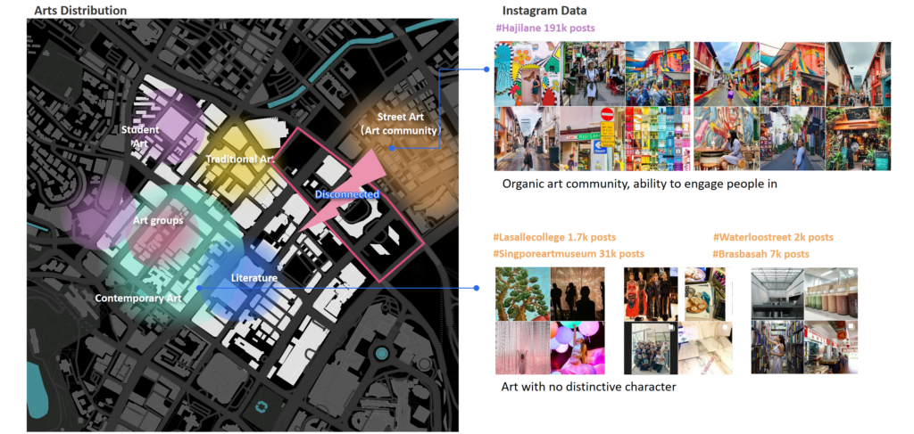
3. the hodgepodge of development and of various use which to an extent, have diluted the Arts Identity.

Explore deeper to the buildings: Cultural assets such as shophouses are not maximizing their potential – Many of the second and third floors of these shophouses are under-utilized, used for storage, worker’s dormitory, etc. Despite the existing problems, there are opportunities that will contribute to a better future for Bugis: The various arts tertiary schools in Bugis translate to thousands of youth demographics each year that offers continuous creativity and vitality to this area. In addition, the ongoing artistic streetscape plan reveals a possible means that embraces better connectivity and the artistic identity of Bugis.

Vision Statement
The insights from the site analysis inspire our vision and strategies.
We envision Bugis as an “Everyday Biennale” – an interactive and inclusive incubator that nurtures ground-up art, celebrates its multi-cultural history, and inspires the community to co-curate Bugis together.
We used Biennale as a metaphor not primarily for its contemporary art but for its intention: Federica Martini, an art historian, suggests how Biennale as site-specific to each country or city, focuses on the spectacularisation of the everyday through art WHILE framing the history of the site and its communities’ collective memory. A biennale-style setting is intended to create a context from within which to engage with everything as an elixir for social exchange.
To materialize our vision, we focus on one specifically important area: the fragmented and insufficient art spaces holding back the organic growth of art. In response, we wish to create more art spaces in Bugis, nurture the organic arts ecosystem that is to materialize the everyday biennale vision. In our planning intervention focus on linkages, they are vines in the art ecosystem and develop both spatial and social linkages using public spaces.
Planning Framework
Spatial structure
We developed 4 types of art zones: the art village zone gathers shophouses, the second floors are adaptively reused as artists’ workshops and the first floor remain as featured bars and restaurants; the open-air gallery zone includes Singapore art gallery, art associations, and auction houses, as a lively art market; the curated retail zone is developed in shopping malls like Bugis junction; the hybrid community zone is new residential development projects.
We link all the zones up using axis: the student art lane is supported by street-side art schools, the traditional art lane we preserve the existing character of Albet mall, the art mart is an art lane run through the malls.
The middle road is the spine of the whole district, which links up all the zones and axis and form a circular route, for this map, we established the framework of spatial linkages.

Art public space
Translating the spatial structure to public spaces, it is identifiable that the new art public spaces connect the fragmented art buildings like schools and associations together. Also, these diverse art buildings add various activities to the public spaces, catalyze social interactions.
Besides, we designed 5 art plazas, acting as centers of different zones. On the plazas of the art village, we designed exhibition & performance houses to keep the plaza alive with fresh art ideas.

Land use adjustment
Small adjustments are made based on the URA master plan. First, we increase the number of open spaces, they form a circulation linkage. Second, we organize the fragmented land use in art village zones into commercial & residential lands. Third, we add more civic institutions next to the plazas.

Mobility network
We adopt road diet to middle road, which is our art spine, it changes from CAT3 to CAT4, meanwhile, pedestrianized some CAT4 roads in art zones, so they transform to CAT 5, we will further elaborate those actions in Urban Design guideline.

General guideline
Before the detailed guidelines, we first developed a holistic guideline map. The black lines represent important street wall edges, some of the edges are designated to street arts, represented by the pink lines, some edges are iconic buildings and colored in blue. Also, in order to build a pedestrian-friendly district, we identify key crossings and junctions of traffic calming; and the pedestrian paths colored in blue-green are bases of adaptive street design.

Art ecosystem
This art ecosystem is what we achieved after the planning intervention, there are three groups of stakeholders: artists, critics & media, and the community, their activities are supported by spatial linkages in Bugis and form lively social connections. To be specific, a young student study in ART SCHOOLS, having the opportunity to exhibit their work on student ART LANE; after graduation, the artist start workshop in the ART VILLAGE and exhibit artwork in nearby ART PLAZA/STREET, where critics and media like to visit and further publish articles and reports about it. This gives opportunities to artists to gain fame and their work might be included in GALLERIES, also they can sell the works in the ART MARKET or auction houses; after years the artist becomes wealthy and sponsor ART SCHOOLS in return.
The ART PLAZA/STREET are the pumps of art circulation, not only connect artists and critics together, but also convey the idea of art to the community, and incentivizing them to co-curate Bugis together.

Urban Design
Adaptive street design
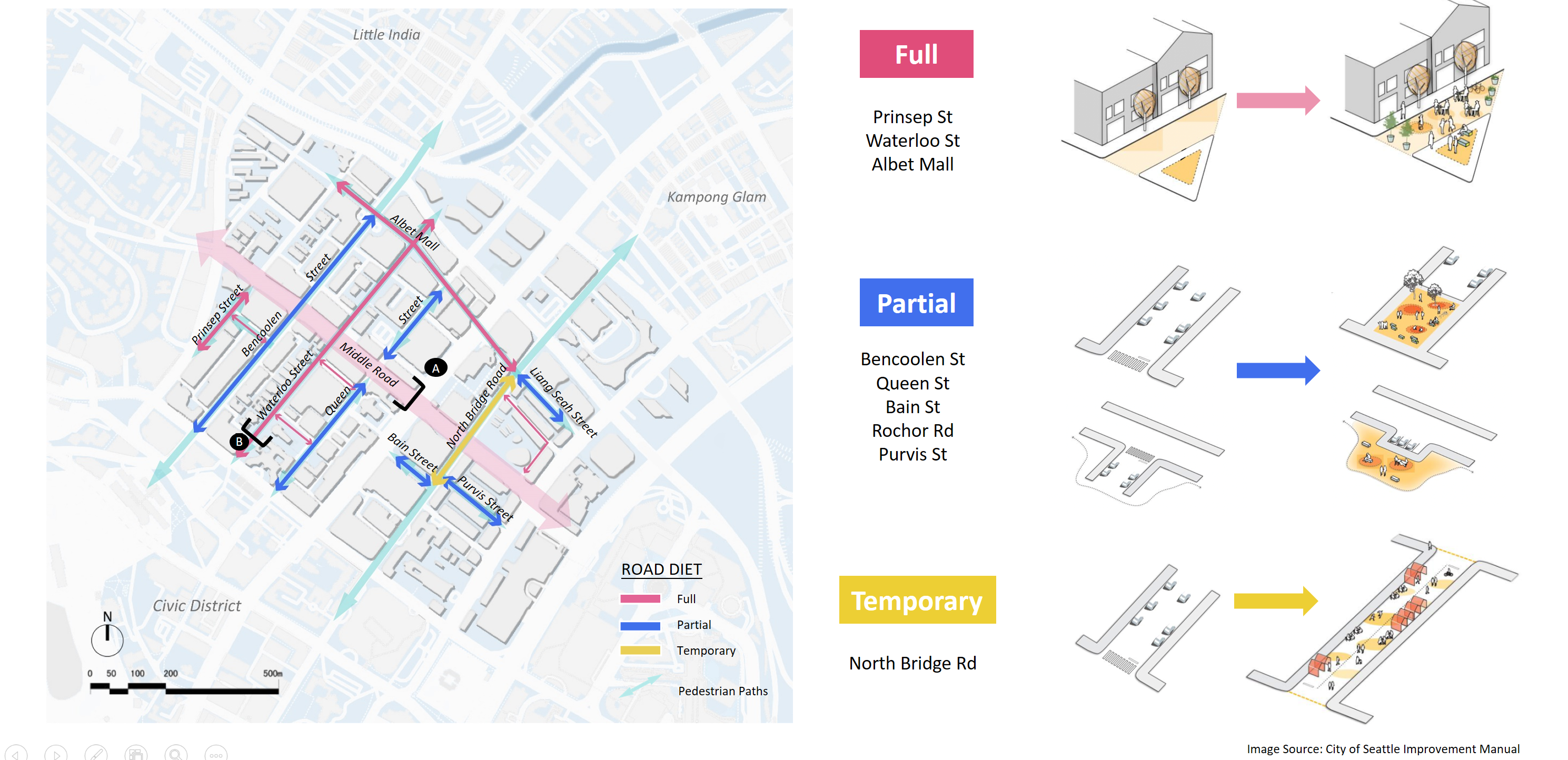
This was from our initial development program of Road Dieting where we intended to reduce the car lanes for an expansion of the sidewalk and public spaces. We have three types of the Full Road Diet:
1. convert cat 4 minor arterial roads into a linear park as seen in the diagram on the top right;
2. Partial Road Diet refers to the partial conversion of the roads into public spaces, at specific periods such as the weekends. For example, we can enclose T-junctions and part of minor lanes such as in Queen St and Bencoolen St, and provide the necessary connectivity between the various art zones;
3. Temporary Road Diet – which would be adopted for special occasions such as the actual Biennale. Where side car parks and lanes would be converted to parklets as seen on the bottom right diagram.
Road section
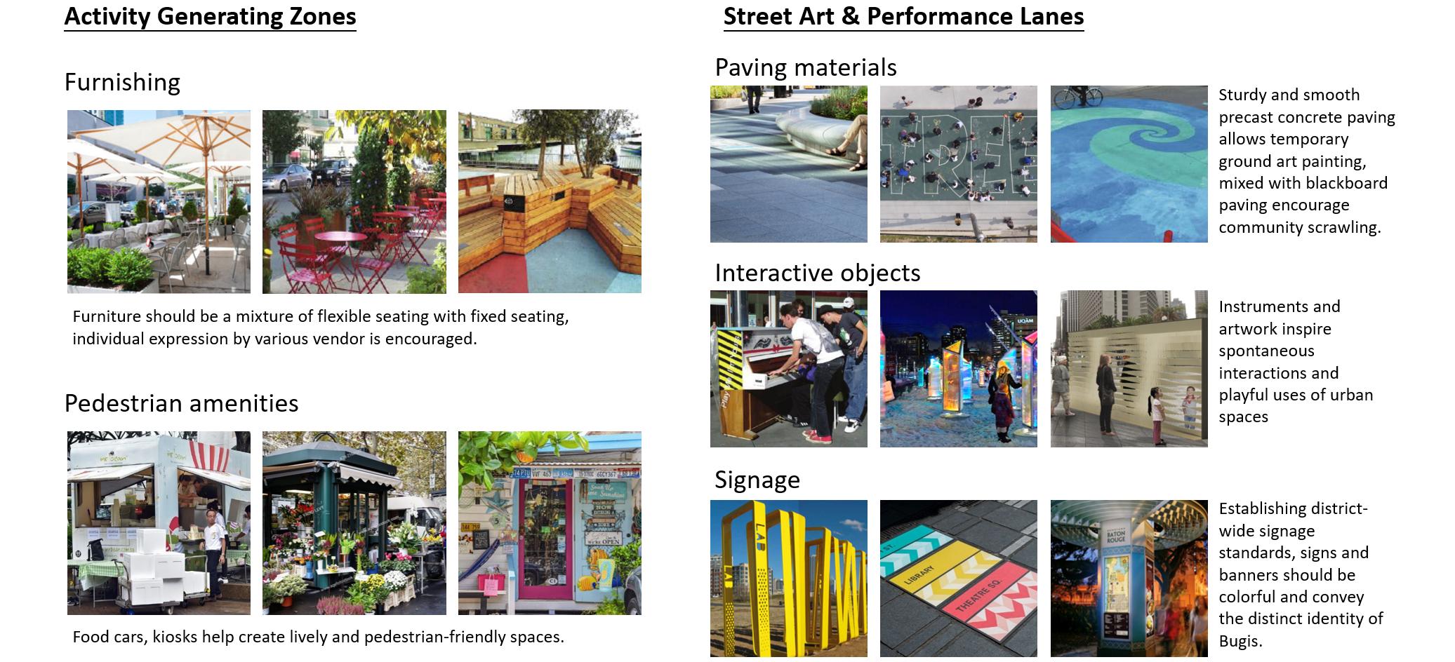
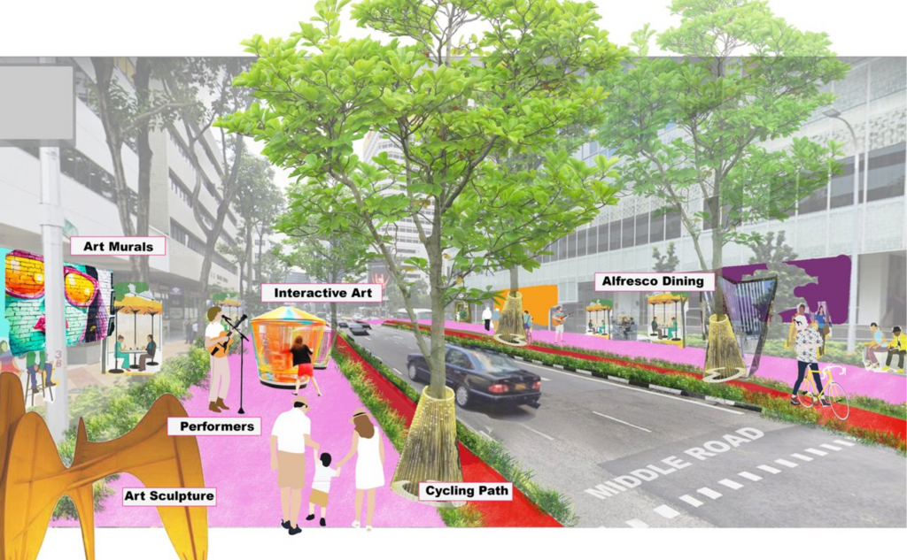
For Middle Road to become our ARTS AVENUE, we propose the conversion of the existing 7 road lane into a cat 5 -2 lane road. This would provide adequate space to cater to the Street art & Performance lanes that take up 7m on each side of the avenue. We are also able to extend the Activity Generating zones to 4.5m and dedicate cycling paths to give holistic connectivity to our Arts Avenue.
In Waterloo street, we adopt full road diet by closing the road and creating an Arts linear park we allow for the spillover of the art group activities unto the street and tackle our earlier site findings that the art institutions are very inwardly and enclosed.

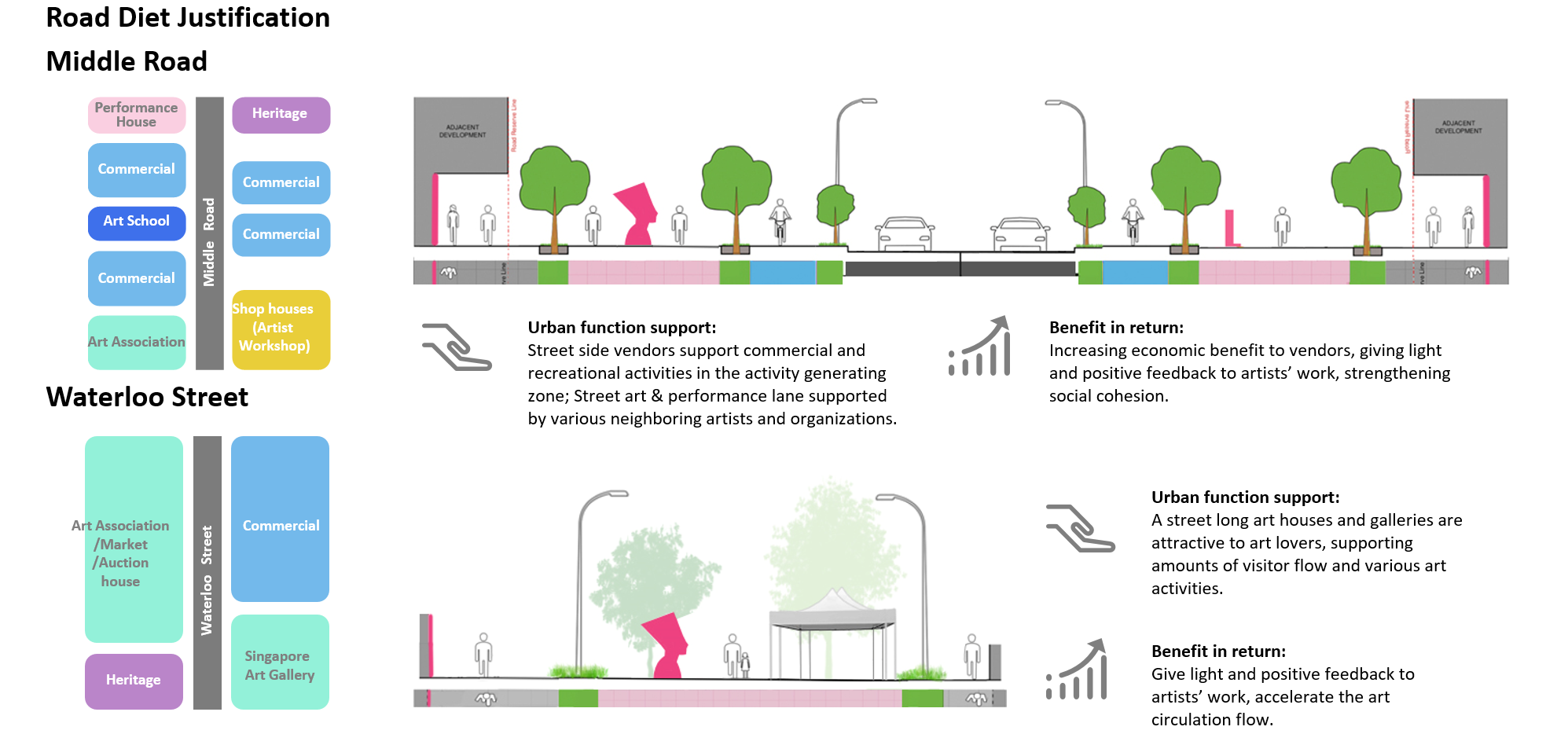
When we assessed how our Road Diet will operate successfully, we looked unto the Urban functions adjacent to it as seen on the left diagram. Evidently, the adjacent tenants will benefit from the intervention increase in footfall and activities for commercial functions and greater public exposure for the arts and heritage sites.
Traffic calming
To complement the road diet, we have a series of traffic calming strategies, to make BUGIS safer and make humans a priority over cars. At the pedestrian junction, we used traffic rerouting, like diverters and line shifts. At the pedestrian crossing, we extend the level of the sidewalk across the street to let pedestrians pass through, and at the crossing across Victoria street, we used vertical deflection measures like speed bump and cushions. At the major crossing of 7 car lanes, we designed an ecological median to slow the traffic speed as well as increase urban tree coverage in Bugis.

Landscape materials
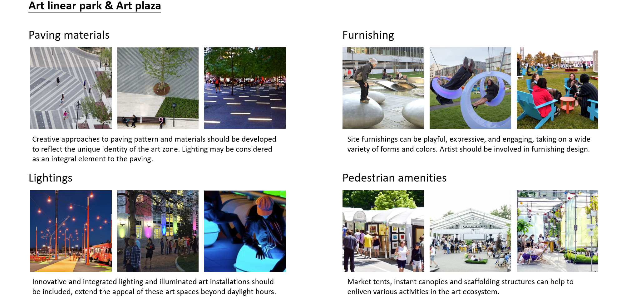
Bugis as an Everyday Biennale
We have covered a wide range of strategies – from the spillover of art murals, co-curation of the art zones, vibrancy created by activity generating zones, connectivity through pedestrian and cycling lanes – hoping to plan for the prevalence of the arts in our everyday lives. An Everyday Biennale implies an overflow of the arts ecosystem which in turn engages us participating in the organic growth of the community.
This is a part of a group project, the project was done with the help of Robin Alviedo and Wang Shiyu.
All the selected contents presenting here are produced by myself.