Master plan that creates a eco-friendly self-sufficient town
Site introduction
Simpang is one of Singapore’s last designated planning areas, nestled on the country’s northeastern coast. It is bordered to the south by Yishun New Town, to the west by Sembawang, and to the east by the Strait of Johor. Significantly, it serves as one of the few coastal habitats in this city-state. The area is renowned for its rich ecological diversity, featuring fertile soils and diverse habitats including mangroves, shrublands, intertidal zones, and secondary forests.
Simpang is the traditional home of the Orang Laut, or “Sea People,” who have long viewed themselves as integral to the natural world, living in harmony with their environment. In this community, nature is barely pressured as residents sustainably harvest only what is necessary for daily life, ensuring the continuous replenishment of natural resources.
The mangroves here are particularly crucial, acting as a reservoir of diverse aquatic plants and natural resources that underpin the traditional economic framework of the region. However, during the 20th century, much of Simpang’s mangrove forests were destroyed, and the Sea People were compelled to abandon their homes, leading to significant ecological and cultural losses.
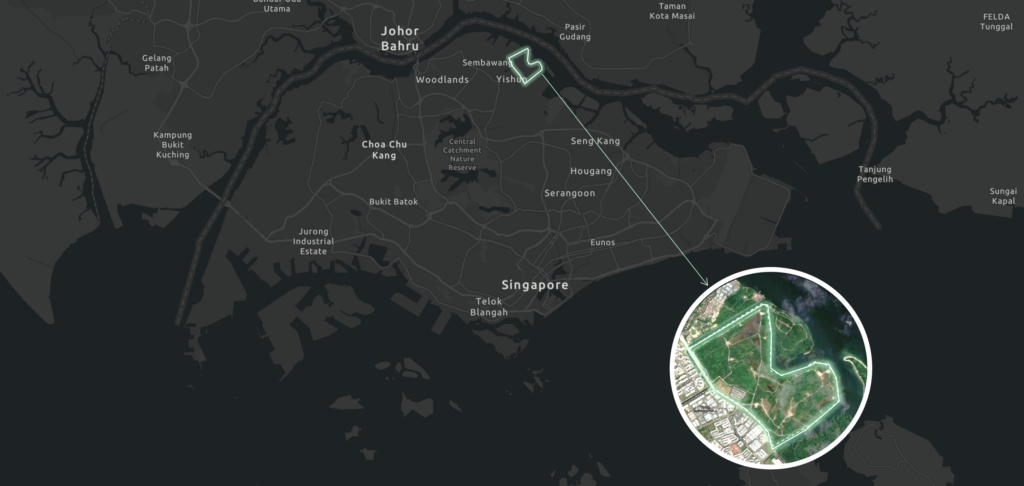
Simpang is a planning area under the Urban Redevelopment Authority’s development guide plan, covering over 8.8 square kilometers. The original 1993 plan aimed to build 20,000 housing units, but this was later shelved to reserve the land for long-term development. In this studio, we focused on a smaller site within Simpang, approximately 3.2 square kilometers, projected to accommodate 60,000 residents.
Our mission is to develop a self-sustaining town by 2040, requiring comprehensive consideration of the opportunities and challenges Simpang will face in terms of lifestyle, culture, identity, mobility, demographics, economic technology, and ecology. The planning process must integrate sustainability, resilience, and climate change adaptation.
Looking into future trends – 2040 and beyond
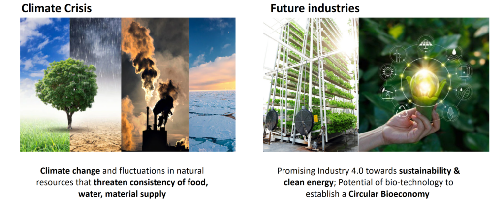
Looking ahead to 2040 and beyond, future industries and technologies will shape our ways of working and leisure. More importantly, it is imperative to address the dire climate crisis threatening our existence. If today’s urban development continues in an unsustainable manner, permitting a parasitic relationship between cities and the environment will only result in harm to the latter.
Vision, objectives, and strategies
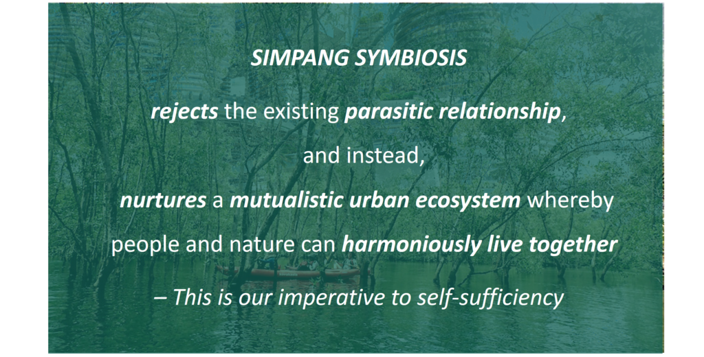
Vision – SIMPANG SYMBIOSIS
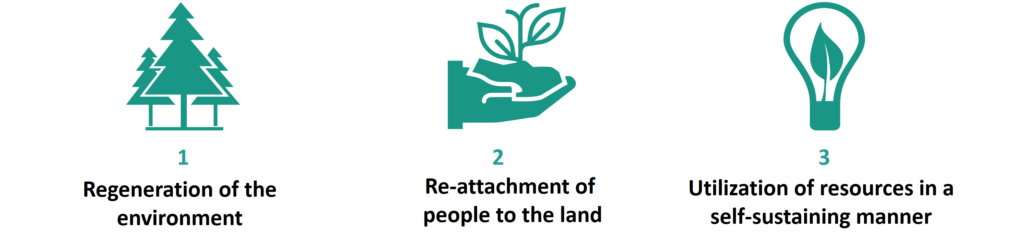
Objectives
Our vision translates into three key objectives: First, to regenerate and repair the environment in a way that allows nature and biodiversity to thrive. Second, we aim to reconnect people with the land, much like the Orang Laut People, who lived in harmony with nature and respected their habitat. This connection will motivate responsible consumption and production practices that are respectful to nature. Third, to adopt future technologies and nature-based solutions that sustainably provide the necessary resources.
Strategies
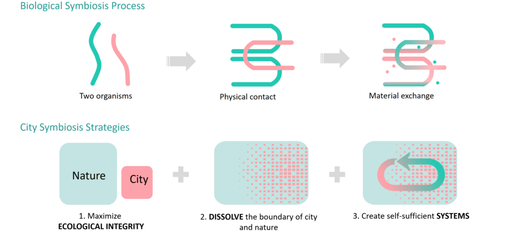
To achieve this, our planning strategies were inspired by the biological process of symbiosis:
It begins between two distinct organisms, typically unequal in nature, followed by their physical contact, which ultimately facilitates the exchange of resources through their interaction.
For our strategies, rejecting the parasitical qualities of cities is crucial; NATURE must be prioritized. Thus, we will maximize the ecological integrity and values of Simpang.
Next, to facilitate physical contact between the city and nature, we adopt a light-touch development approach. This means dissolving the boundaries between the city and nature, allowing the city to gradually disappear into nature and reconnecting people with the land.
Lastly, we catalyze the exchange of materials by creating various necessary self-sufficient systems. In this process, both humans and nature benefit from each other. We will elaborate on the approaches of each strategy in the subsequent sections.
Maximize ecological integrity
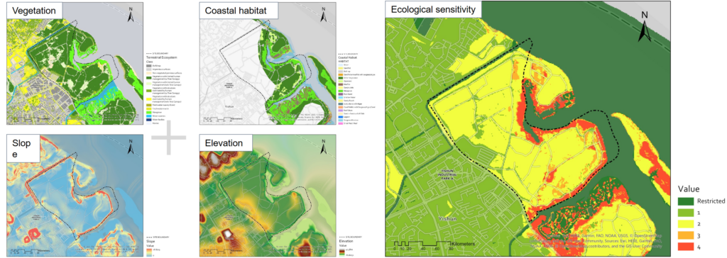
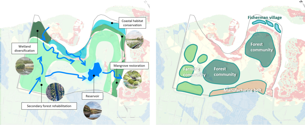
To protect the ecology, we must first understand what is valuable and where these valuable assets are located within our site. Utilizing evaluation principles that consider vegetation, coastal habitats, slope, and elevation, we derived a composite ecological sensitivity map using GIS. This map enables us to identify non-tradable zones along the coastlines to preserve the integrity of coastal and mangrove habitats. Conversely, the brownfield site adjacent to the Yishun Industrial Estate exhibits the lowest ecological impact from development.
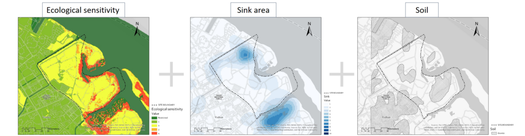
We then proceeded to identify which areas within the site are more suitable for development. We utilized sink areas and soil conditions as metrics for this assessment. Consequently, we created a developable area map, where land areas are graded according to their developability. This map forms the foundation of our approach to ecological restoration and protection, as well as our overall planning structure.
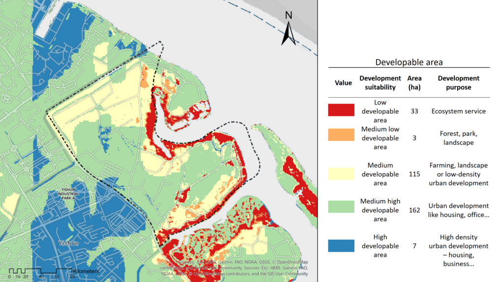
For areas with low to medium-low developability, our main approach to ecological restoration focuses on rehabilitating mangroves, secondary forests, and reintroducing waterways lost to prior development. We hypothesize that traditional green and blue networks are no longer sufficient, and instead, nature should envelop our urban developments. Meanwhile, the medium, medium-high, and high developability areas also shape our structural map. Farming communities will be located in the northwestern regions where alluvial soil enhances crop production. Our forest communities, integrated with urban elements, will be situated in areas with granite formations that provide a stable foundation for development. The manufacturing belt, which includes light manufacturing and waste management facilities, will be positioned adjacent to the Yishun Industrial Estate to promote productive synergy.
Dissolve city & nature boundaries
New land use – Ensuring urban-nature integration
To redefine the relationship between the city and nature, we are not content with existing land use patterns. Consequently, we propose two new land use typologies as vital legislative tools for ensuring the integration of urban areas and nature.
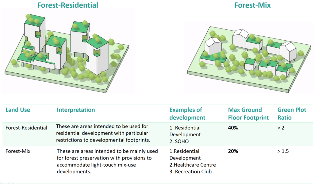
The first typology is ‘Forest Residential’. These areas are designated for residential development but with strict limitations on developmental footprints; the green plot ratio should exceed 2. This requirement is designed to allow flora to thrive and integrate into the living environment.
The second typology is ‘Forest-Mix’. These areas are primarily aimed at preserving forests while allowing for light-touch mixed-use developments, such as residential spaces combined with healthcare or recreational functions.
Parcellation – Facilitating horizontal dissolve
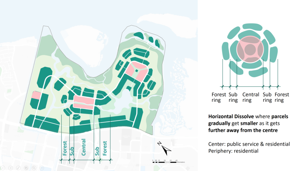
Spatially, the ‘dissolve’ concept translates into the parcellation of land. Urban plots will dissolve outward from the central ring toward the periphery, nearer to the forest, meaning that land parcels will gradually decrease in size as they move away from the center, as illustrated in our map. The urban center will accommodate public services and mixed uses, while the periphery will focus primarily on residential land use.
New land use placement – Hiding plots within forest
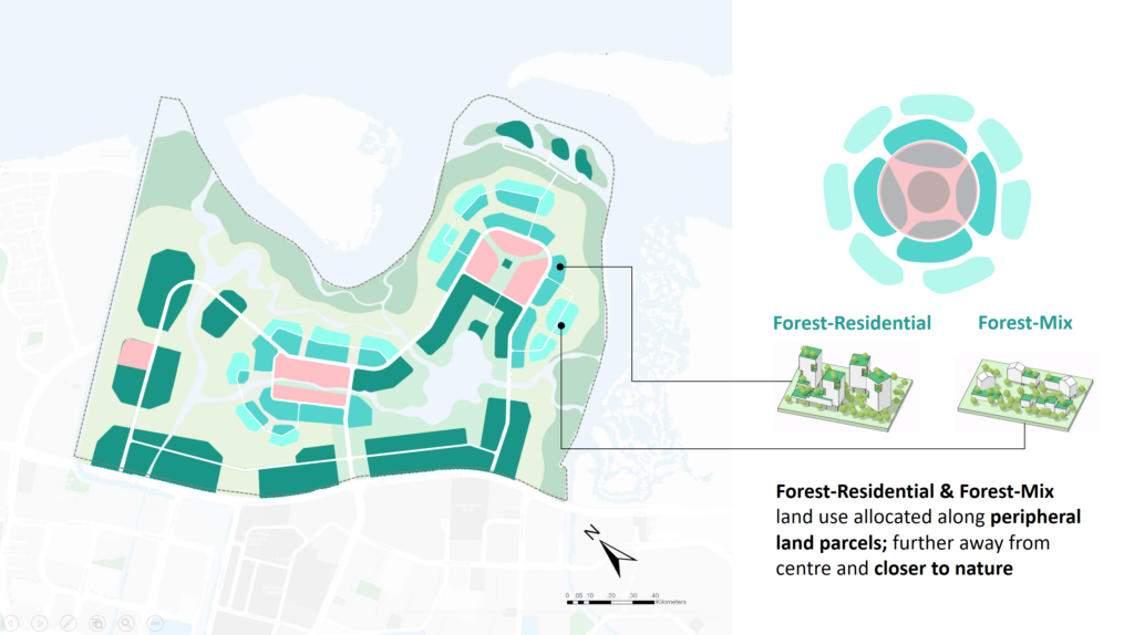
Smaller land parcels on the periphery will be allocated to Forest-Residential and Forest-Mix typologies, with denser Forest-Residential areas closer to the central ring and low-rise Forest-Mix scattered throughout the natural landscape. This arrangement will allow urban land parcels to gradually blend into the forest.
Road network – Stitching dissolved parcels
Dissolved land parcels will be interconnected through a network of roads: Category 3 roads will facilitate inter-center movements, while Categories 4 and 5 roads will connect smaller land parcels within communities.

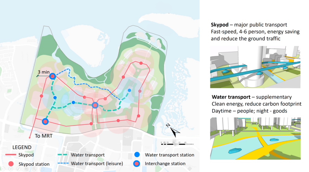
Special transit modes – Reducing land demand
Moreover, we have adopted Special Transit Modes to minimize urban land demands and promote natural growth. Skypods, elevated above ground, offer a light, high-speed, point-to-point transport solution, serving as the primary public transportation for groups of 4-6 people across all communities in SIMPANG and connecting to external MRT stations. Water transport will serve as a supplementary mode for people, logistics, and leisure activities. The buffer zones on the map indicate a 3-minute walking distance from each station, ensuring that 95% of the living areas are well-served by these two transport modes.
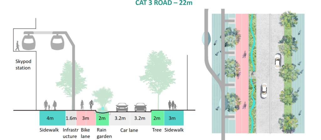
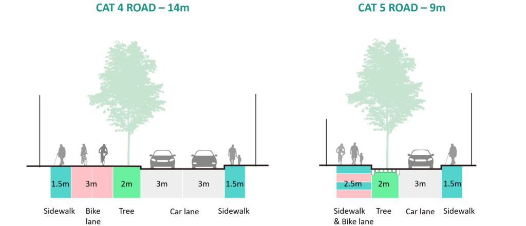
Road sections – Less car lanes & more active mobility
Our road design for Category 3 roads includes a total width of 22 meters, featuring two-way car lanes separated from pedestrian pathways by a 2-meter green buffer. The Skypod infrastructure occupies 1.6 meters but will be integrated within the buildings. Category 4 and 5 roads will measure 14 meters and 9 meters in width, respectively, as shown in the diagram.
Public space – From manicured to natural
For public and community spaces, we have strategically designed a gradual transition from manicured landscapes, such as lakeside parks and forest gardens, to more untouched natural environments, like forests and primitive mangroves. Community spaces are organized from centralized commercial districts to scattered community centers.

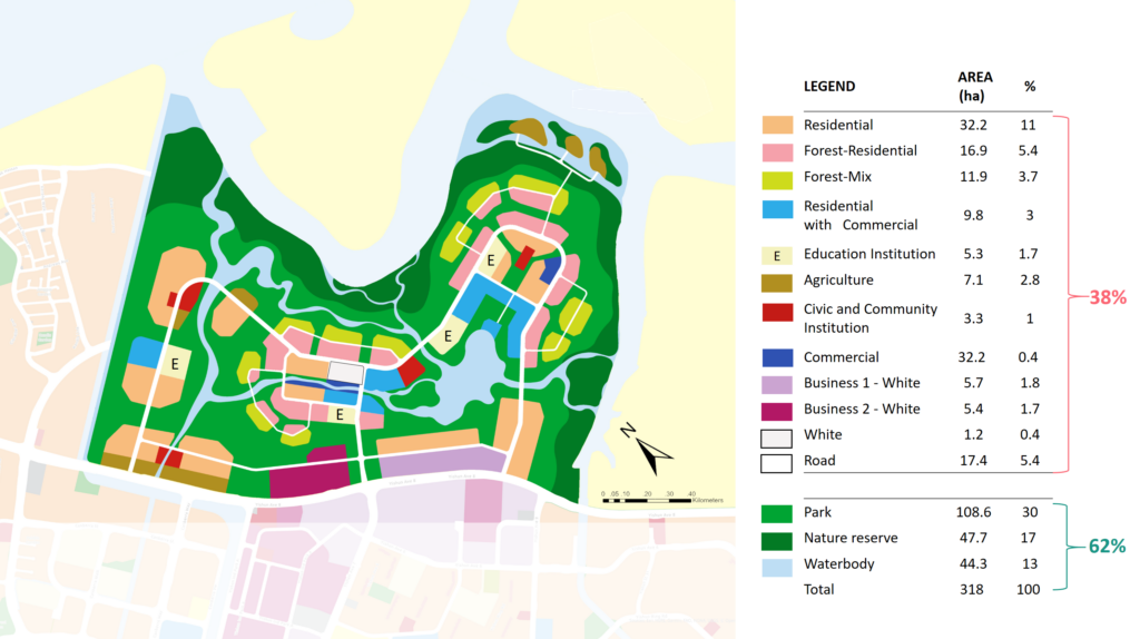
Land use – Balancing urban and nature
Next, our “dissolve strategy” stems from our need to balance urban areas with nature. As such, our land use distribution allocates only about 40% of the land to urban activities, allowing the remaining 60% for nature to flourish. Specifically, 30% of the land is designated as forest park, 17% as nature reserve, and 13% as intra-waterbody. From the table, you can also see that close to 30 hectares are designated for forest-residential and forest-mix uses. This balance is essential for symbiotically dissolving the boundaries between the city and nature.
Massing – Horizontal & vertical dissolve
All the dissolve strategies will facilitate dissolving through massing. As shown in the diagram on the left, while the general building height decreases from center to periphery, the building footprint also transitions from compact areas to a fragmented periphery. The buildings on the periphery will have a high green plot ratio as mentioned in our new land use, allowing nature to gradually blend into the urban area.
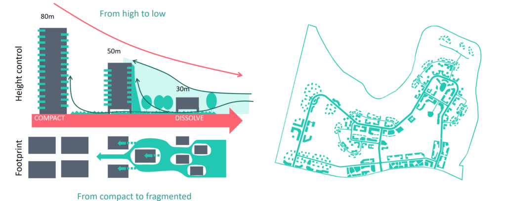
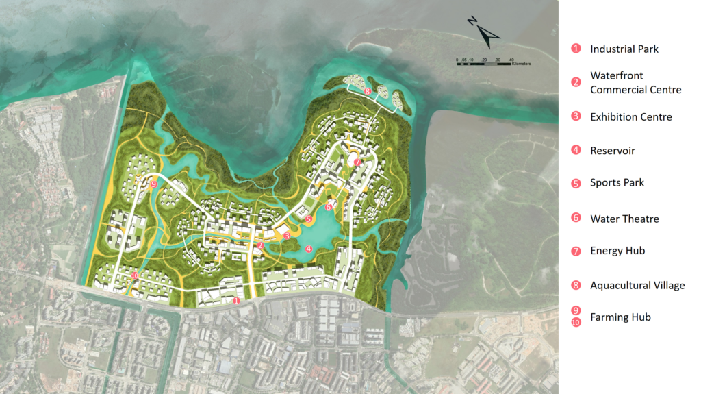
Master plan – From compact to fragmented
Based on our dissolve strategies, we developed a master plan that illustrates how building footprints and layouts transition from compact to fragmented, how nature is preserved, and how it integrates into urban development areas. Ecologically sensitive areas are well preserved, with development density transitioning from high to medium developable areas we identified earlier. Most people’s activities will occur in the center.
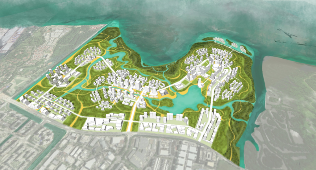
Skyline – Gradual change from high to low
The 3D model clearly depicts the outcome of our vertical dissolving strategy: taller buildings at the core of each urban center, ranging from 50 meters in height at the farming community to 115 meters in height.
Create self-sufficient SYSTEMS
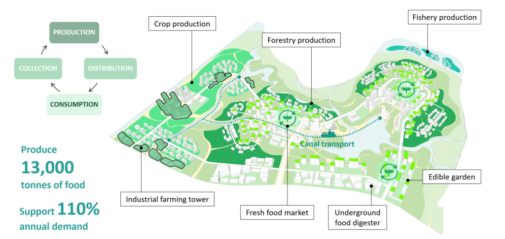
Food system – Living within our means
For food, produce from residents can be sold alongside mass-produced items at the fresh food marketplace. At the community market, excess food items at the food and beverage level can be traded, and limited amounts of unsold food can also be collected by those in need, in an effort to reduce food waste.
Lastly, food waste will be collected through a pneumatic waste conveyance system and sent directly to underground food digesters. The food waste can then be composted and reintroduced into the food production stage, thereby closing the loop.
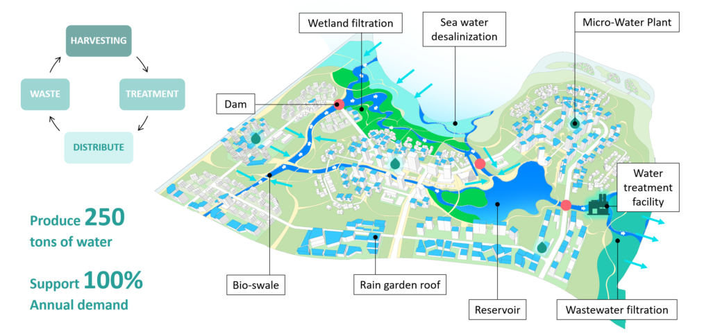
Water system – Technological & natural synergy
Our water system ensures complete self-sufficiency in domestic water consumption.
Rainwater is harvested across the urban landscape, including gardens, roofs, and bioswales along river channels. Once collected, it flows through an underground network beneath our roads to a water treatment facility near the eastern mouth of our reservoir, where it is processed into potable water for domestic use.
In addition to serving domestic needs, an “incomplete” filtration process allows wastewater to be sufficiently cleaned to be non-toxic before being redirected into the mangroves at the site’s boundary. This method uses remnant bio-materials in wastewater as nutrient-rich fertilizers to enhance the growth of mangroves while alleviating the load on our water treatment facilities.
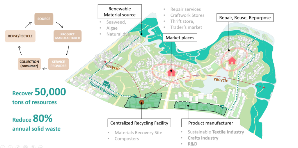
Material system – Waste minimization
Our material system is built on a circular local economy, where goods are produced using locally sourced renewable materials. The lifecycle of products is extended through waste retrieval and upcycling processes.
Seaweed, algae, and native dyes are harvested and converted into textiles for the production of wearables like clothing and household items. This strategic selection of the advanced textile and crafts industries, alongside R&D, maximizes the potential for industrial symbiosis and the success of the circular economy.
Service providers at marketplaces model consumption waste minimization. Local craftsmen industries help keep products in the consumption cycle longer by repairing, upcycling, and repurposing them. Solid waste materials generated within the community are sorted at a centralized facility and recycled back into the manufacturing process. To close the cycle, products designed to be biodegradable at the end of their lifecycle can be composted, returning nutrients to their source. This system is projected to recover 50,000 tonnes of resources and reduce up to 80% of annual solid waste.
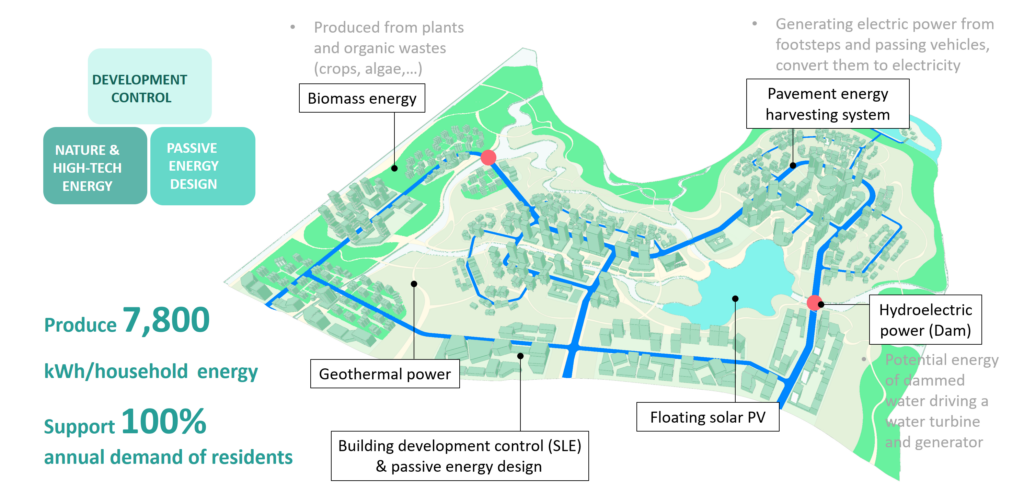
Energy system – Harnessing ‘by-products’
Our energy solution combines natural, technological, and regulatory strategies to harness by-products from both city and nature. A major strategy for energy self-sufficiency involves development control regulations and passive energy designs to minimize building-level energy demand. To offset remaining needs, floating solar PV panels are deployed in central open reservoirs and near the fishing community. Hydroelectricity is generated as nutrient-rich wastewater is released into the mangroves. Additionally, smart road infrastructure captures kinetic energy from vehicular and pedestrian traffic throughout the site.
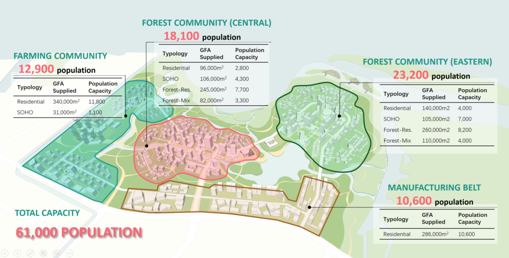
Capacity – accommodating 60,000 people
In conclusion, Simpang Symbiosis strikes a balance between city and nature, accommodating a projected population of 60,000.
Over two-thirds of residents will live in forest communities, with a variety of housing typologies from SoHo to our innovative forest-residential and forest-mix living arrangements. The remaining third will reside within the manufacturing and farming communities.
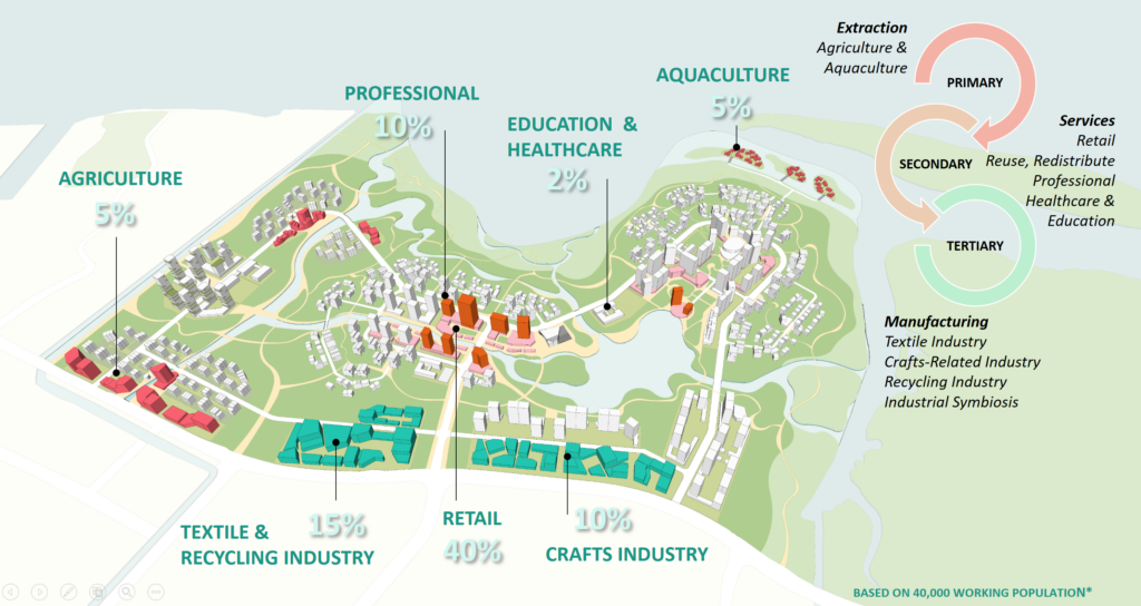
Circular economy – Job creation
Simpang Symbiosis will also create the necessary jobs for the population and more importantly, facilitate a circular economy. This is achieved by addressing the primary, secondary, and tertiary economic sectors and is the outcome of our third strategy—creating self-sufficient systems that spur the needed paradigm shift towards self-sufficiency.
This project was made possible through the collaboration of Athira Radhakrishnan, Gu Qianhua, Robin Alviedo, Wong Yi Suen, and Wang Shiyu.